
What to Know
- A winter storm is set to hit the D.C. area and could drop snow on Sunday evening before shifting to sleet and rain during the Martin Luther King Jr. Day weekend.
- The largest snow totals are for areas along Interstate 81 and the Shenandoah Valley, where a winter storm warning is in effect.
- The Virginia Department of Transportation urged people to stay off the roads Sunday. Travel impacts would likely continue Monday and possibly Tuesday.
A winter storm is set to slam Washington, D.C., Maryland and Virginia over the Martin Luther King Jr. Day long weekend with accumulating snow and ice.
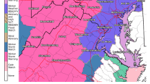
A winter storm warning is in effect from Sunday morning to Monday morning for Frederick County, Maryland, plus Culpeper County, northern Fauquier County and western Loudoun County, Virginia, plus areas along the Blue Ridge mountains, the National Weather Service says.
Snow totals of 2-4 inches are expected west of D.C. in areas like Frederick and Loudoun counties, and power outages or falling trees are likely due to ice, the National Weather Service says.
We're making it easier for you to find stories that matter with our new newsletter — The 4Front. Sign up here and get news that is important for you to your inbox.
A winter weather advisory has been issued from 1 p.m. Sunday to 1 a.m. Monday. It impacts Washington D.C.; Alexandria, Arlington Fairfax, Loudoun, Prince William, Stafford counties, plus Falls Church, Manassas and Manassas Park in Virginia; and Montgomery and Prince George's counties in Maryland. Here’s a full list of weather alerts.
The Virginia Department of Transportation urged people to stay off the roads Sunday.
Weather
Latest weather forecast, live radar and weather maps for Washington, D.C., Maryland and Virginia

Storm Team4 has declared a weather alert for active and impactful weather including snow, freezing rain, ice and rain.
After a frigid cold Saturday with temperatures stuck in the 20s, expect a storm to dump wintry precipitation starting Sunday afternoon.
The D.C. area will likely see snow transition to ice and rain. Southern Maryland can expect mostly rain. Parts of far western Maryland are in line for heavy snowfall that could total 5-9 inches.
What time is it supposed to snow Sunday?
Expect the storm to arrive as all-snow Sunday afternoon. The winter storm will hit the southwestern suburbs first, Storm Team4 says.
From 1 p.m. to 5 p.m., accumulating snow is likely near D.C.
Between 5 p.m. and 8 p.m., the winter storm is set to transition from snow to ice. That transition will happen earlier for eastern suburbs and later for western suburbs.
Sunday night into Monday morning, the D.C. area will see more rain, along with windy weather. The rain could be heavy at times.
The winter storm will continue to impact the area on Monday morning. Martin Luther King Jr. Day will also be blustery and cold with highs in the 40s.
A hard re-freeze overnight could cause some tricky road conditions Tuesday.
Snow totals expected in D.C., Maryland and Virginia
How many inches of snow are we getting this weekend? That depends on where you are.
In the D.C. metro area, 1 to 3 inches of snow may fall. Near the District, totals could be just an inch-and-a-half, Storm Team4 says. Ice accumulations of one-tenth of
an inch are also possible, the National Weather Service says.
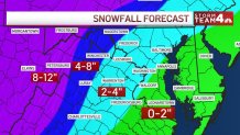
The heaviest and most consistent snowfall is expected along I-81 and in the Shenandoah Valley where 5 to 9 inches is possible.
In Southern Maryland, 0 to 2 inches is possible. Expect mostly rain.
Enjoy the winter wonderland and get your sledding or snowball fights in while the snow is falling. Any rain would push the snow down.
How to prepare for a winter storm and road conditions
Virginia Gov. Ralph Northam declared a state of emergency to allow quick coordination in response to snow, noting that parts of the state are still recovering after the Jan. 3 snowstorm that left a foot or more of snow in some areas.
Road conditions will likely be better than they were during that storm, which closed many schools for multiple days. Because Sunday's storm is set to begin as all-snow, chemicals on the roads should be more effective. Plus, the Martin Luther King Jr. Day federal holiday on Monday means fewer commuters and more space for road crews to work.
The Virginia Department of Transportation is treating roads ahead of the snow and ice. The agency is trying to avoid a repeat of the fiasco on Interstate 95 seen almost two weeks ago, when thousands of drivers were trapped, some for 24 hours.
Take advantage of dry weather to be as storm-ready as you can. Fill up your car’s gas tank, visit the grocery store or pharmacy and prepare deicing materials for stairs and sidewalks.
Here are four tips for staying safe this winter and our guide on packing an emergency kit to keep in your car.
