Editor's note: Go here for the latest forecast.
Many residents of the D.C. area could see snowflakes this weekend — but the closer we get to Saturday, the less likely it seems that we'll get much.
Storm Team4 is tracking a winter storm expected throughout Saturday and into early Sunday. A mix of rain, snow and possibly ice is expected during the first half of Saturday, before it changes into all rain for much of the region. Areas to the north and west of the D.C. metro area will see the largest effects of the storm.
The rain-snow line is often a tricky part of winter storm forecasting, and it's set to be in play in the evolving forecast for this winter storm.
We're making it easier for you to find stories that matter with our new newsletter — The 4Front. Sign up here and get news that is important for you to your inbox.
“The big question is: Where is that rain-snow line going to set up?" Storm Team4 Chief Meteorologist Doug Kammerer said.
It’s still too early to talk about possible snow accumulation totals.
Here’s where snow and rain are expected
Storm Team4 Meteorologist Amelia Draper laid out where more snow is expected.
Red Zone: Areas of Maryland and Virginia farther away from the metro area will see the biggest impacts. “This is looking like mainly a snow event for you,” Draper said. The storm may end there as a wintry mix or rain.
These locations include:
- northern Fauquier County, Virginia
- Frederick County, Maryland
- western Loudoun County, Virginia
- upper Montgomery County, Maryland
- Page County, Virginia
- Rappahannock County, Virginia
- Warren County, Virginia
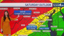
Yellow Zone: The District and parts of Maryland and Virginia bordering the Capital Beltway will get a wintry mix, with snow arriving Saturday morning and then changing over to all rain. Not much snow accumulation is expected.
These areas include:
- D.C.
- Fairfax County, Virginia
- Manassas, Virginia
- lower Montgomery County, Maryland
- northern Prince George’s County, Maryland
- Prince William County, Virginia
Green Zone: Primarily rain, and possibly some snow flurries, are expected in parts of Maryland. These areas include:
- Calvert County
- Charles County
- St. Mary’s County
- southern Prince George’s County
The forecast models differ on where the rain-snow line may fall, but the general consensus is that more snow would fall north and west of D.C.
Rain is more likely farther to the south and east.
Here’s what we know about the storm timing
One computer model says we’ll still be dry at 6 a.m. Saturday and that we’ll see snow in the D.C. metro area toward midday. Rain will move in that afternoon, and the storm system will start to wind down overnight Saturday.
So, will be shoveling snow or skipping tests at school on Monday? As of right now, it doesn’t look likely.
Here's the forecast for the rest of the workweek
Before the weekend, expect mostly calm and cool weather. High temperatures will be in the 40s, with breezy winds on Thursday. Lows will be in the mid 30s on Thursday and mid 20s on Friday.
Storm Team4 winter weather outlook
If you want snow, and lots of it, Storm Team4’s winter weather outlook said this could be your year.
Storm Team 4 predicted:
- 22"-30" of snow this winter for the I-95 corridor and the D.C. metro area
- 15"-22" in our southern zones
- 30"-40" in the western suburbs
Go here to see the full winter weather outlook.
Weather radar:
Download the NBC Washington app on Apple and Android to use the weather radar on your mobile device.