
Not a big fan of snow? Last winter was probably perfect for you. Snow lovers haven't gotten a good amount since January 2019, when more than 10" fell in the D.C. area.
But get those waterproof boots and snow shovels ready — because if you want snow, and lots of it, Storm Team4 says this could be your year.
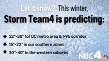
Storm Team 4 is predicting:
- 22"-30" of snow this winter for the I-95 corridor and the D.C. metro area
- 15"-22" in our southern zones
- 30"-40" in the western suburbs
We're making it easier for you to find stories that matter with our new newsletter — The 4Front. Sign up here and get news that is important for you to your inbox.
If conditions come together, we could see one or two big snowstorms that really make their mark on the winter of 2023-2024.
We should see an active storm track this winter, with numerous storms that will produce rain at times and snow at other times. Temperatures will be above average for a good chunk of this winter, but there will be cold bouts as well. All of this will add up to the potential for some big East Coast storms.
We expect December to be about average or a little bit above. January will have near to slightly below average temperatures, while February could be our coldest month — and our stormiest.
Recent winters have seen a shortage of snowflakes
Our last blizzard was all the way back in 2016. As one of the biggest snowstorms in D.C. history, it shut down the city for days.
But since then, six out of our past seven winters have seen below-average snowfall. The winter of 2018-2019 was the only time we surpassed the average of 13.7".
Over these past seven years, we've averaged just 6.8" of snow per year — and in two of those years, we didn’t even get a single inch. The winter of 2019-2020 saw just 0.6", and last winter was one of the least snowy of all time, with a measly 0.4". Last winter was also one of the warmest of all time.

A snowy outlook for winter of 2023-2024
It has been either feast or famine when it comes to snow over the last few years, but lately it’s been more famine.
Now, as we look toward the winter of 2023-2024, we could be feasting quite a bit more.
The National Oceanic and Atmospheric Administration (NOAA) is currently predicting above-average temperatures for our region this winter, and we agree with this. They are also predicting above-average precipitation in our region — and we agree with this as well.
El Niño has set up in the equatorial Pacific, and that could lead to more snow, including the potential for some big snowstorms. El Niño has a profound influence on the weather around the globe. In our area, it normally means more snow, but let’s dive into the details.
What to know about El Niño's effect on winters in the DC area
This developing El Niño is looking to be a strong one. Looking at previous years with similar conditions, the D.C. area has hit the jackpot in regards to snowfall almost every time.
We reviewed four similar El Niño winters: 1957-1958, 1965-1966, 1972-1973 and 1982-1983. The average snowfall over those four winters was 24" — but we said we hit the jackpot only almost every time. The winter of 1972-1973 was actually our least snowy winter on record, with just 0.1". While El Niño might have been similar that year, other factors are not, and Storm Team4 is taking that year out of the equation.
So over those other El Niño winters (1957-1958, 1965-1966 and 1982-1983), we got an average of 32.1" per winter. That’s a big number — and Storm Team4 expects a big winter.
Other factors involved in predicting a snowy winter
There are numerous other factors at play in addition to El Niño. For example, warm water in the Atlantic Ocean and the Gulf of Mexico should help produce more moisture during storms in the D.C. area. The warm water of the Pacific should also help to bring more moisture in from the west.
Another factor to consider is Siberian snow cover in October and early November. Normally, cold and snowy weather there during this time period could mean a colder-than-average winter for us and one with more snow. This year, snowfall in that area of the world has been a little late, but it's starting now to really increase.
Storm Team4 also reviews something called the Quasi-Biennial Oscillation (QBO). This takes a look at winds in the stratosphere. Currently, the QBO is negative. When this happens, we look for more cold weather outbreaks in the eastern U.S., and that could lead to more snow.
