Editor's Note: This story is no longer being updated. Go here for the latest Storm Team4 forecast.
Storms around the DMV started to wind down during the Thursday evening rush.
The temperature change the storm brought in its wake, on the other hand, is sticking around.
Storm Alerts
We're making it easier for you to find stories that matter with our new newsletter — The 4Front. Sign up here and get news that is important for you to your inbox.
The D.C. metro area and surrounding locations were under a severe storm watch until 10 p.m.
But not everyone in the region got rain: The strongest storms rolled over the areas south and east of D.C.
A line of storms hit the Interstate 95 corridor during the evening rush.
Weather
Latest weather forecast, live radar and weather maps for Washington, D.C., Maryland and Virginia


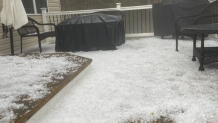
The main threats with the storms were damaging wind gusts and heavy rain -- and, in Charles County, Maryland, golf-ball sized hail.
Temperature Drop
While not everyone around the region saw that heavy rain, everyone will feel the temperature change.
After a record high temperature of 87 degrees on Wednesday, and temperatures in the 80s again on Thursday, temperatures plummeted about 20 degrees in two to three hours on Thursday evening.
The high of 86 degrees around 4 p.m. Thursday afternoon dipped into the 60s by 6:45 p.m. that same day.
Future Forecast
Bring a sweater if you head anywhere Friday or over the weekend as temperatures dip after the rain. And with a chance of frost and freeze in some places overnight, you'll need a jacket for the evening, overnight and early morning hours.
Much of the region will struggle to make it out of the 50s on Friday, with plenty of clouds lingering.
Saturday will bring more clouds, and continued cool weather with highs in the 50s.
Sunday will warm slightly and see a return to sunshine, but temperatures will stay on the cool side in the low 60s.