Editor's Note: Go here for the latest forecast and weather impacts on Thursday, Dec. 15.
A winter storm will bring sleet, freezing rain and ice to parts of the Washington, D.C., area Thursday.
Storm Team4 declared a weather alert for overnight sleet that will turn into drenching rain throughout Thursday. West of D.C., along the Interstate 81 corridor, significant icing is possible.
Several schools districts will be closed or start classes late on Thursday. Prince William County will have a virtual learning day.
We're making it easier for you to find stories that matter with our new newsletter — The 4Front. Sign up here and get news that is important for you to your inbox.
Track all school closings and delays here.
Expect a high-impact event Thursday morning with dangerous freezing rain to the west. Heavy rain will continue through the day past the evening rush hour to the east.
Precipitation will lower the temperature with temperatures approaching freezing to the north and west.
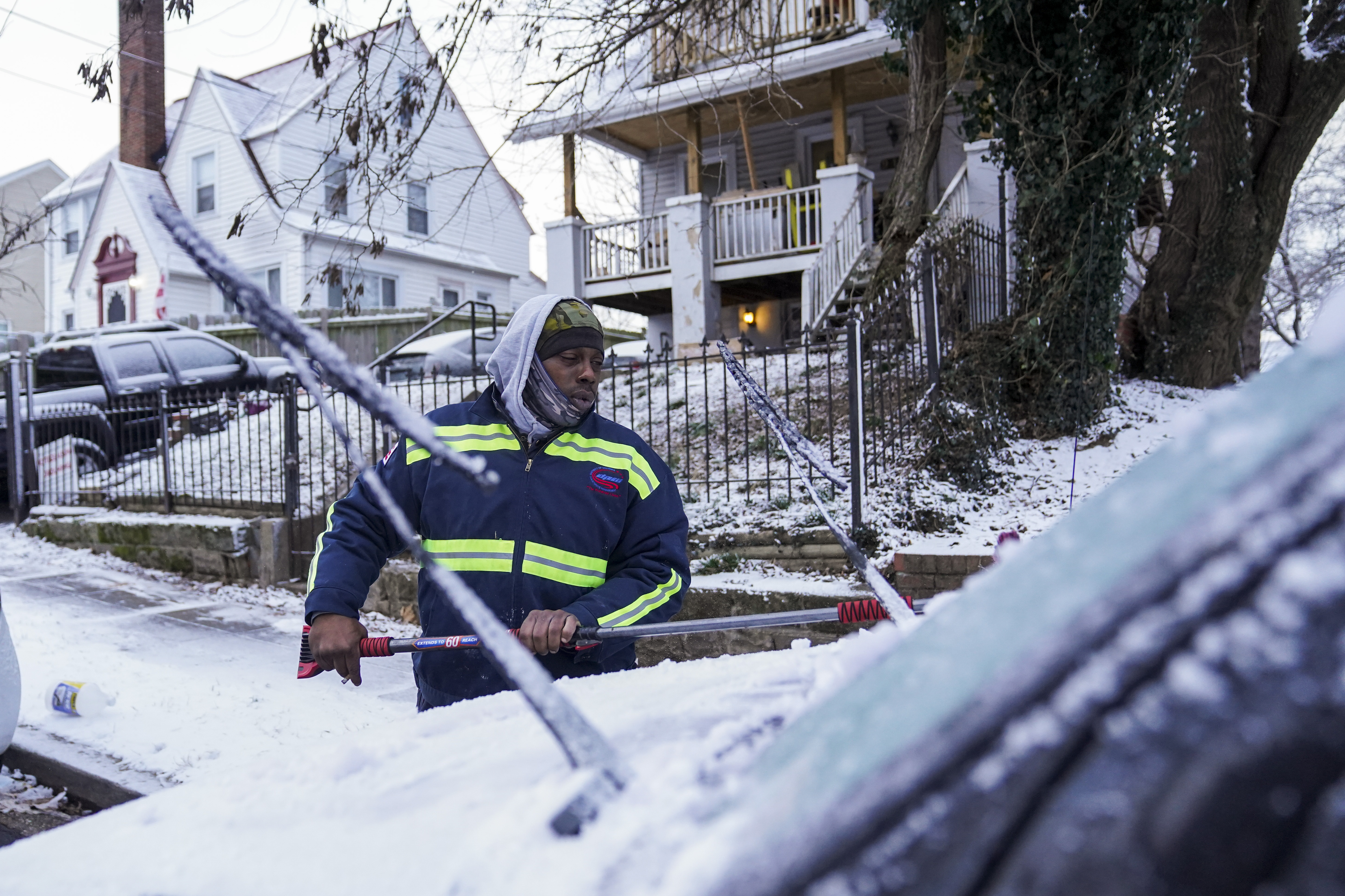
Crews in Virginia, Maryland and the District are treating the roads Wednesday, including by spreading brine on overpasses and bridges.
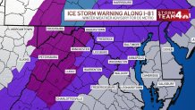
Winter Weather Advisory for D.C. Area
A winter weather advisory starts at 10 p.m. Wednesday and continues until 1 p.m. Thursday, the National Weather Service says.
Areas impacted include Washington, D.C.; Prince George’s and Montgomery counties in Maryland and Arlington, Alexandria, Fairfax, Loudoun and Prince William counties plus nearby cities in Northern Virginia.
If you have friends, family or business near Martinsburg, West Virginia; Cumberland, Maryland, or Winchester and Luray, Virginia, heads up that an ice storm warning will be in effect from Wednesday evening into Thursday. The National Weather Service says significant icing is expected.
“If you are under an ice storm warning you want to take it really seriously,” Storm Team4 Meteorologist Amelia Draper said.
Areas under an ice warning should plan for power outages, according to Draper.
The D.C. metro area will see a period of freezing rain and/or sleet Thursday morning, but that will be all rain by 9 or 10 a.m. Up to 2 inches of rain is possible. Prepare for a slow, rainy morning commute.
Montgomery County and areas to the west will deal with freezing rain and sleet with p two-tenths of an inch of ice. Roads will be slick and should be avoided Thursday morning. It should be just rain by midday or early afternoon.
In the mountains, up to a half inch of ice is possible and could cause power outages. Avoid traveling in the area Thursday.
To the south, expect just a rain event.
Commuter & School Impacts
Commuters will not be impacted by weather on the road Wednesday. That will change Thursday morning, when drivers are likely to see rain and ice.
Due to possible icy road conditions, Metro advised customer to prepare for Metrobus service impacts on Thursday.
"If you can delay or work from home tomorrow, that is going to be the way to go. The messiest of the weather falls tomorrow between 6, 9, 10 a.m.," Draper said.
Delays are possible for more schools north and west of D.C., including Loudoun and Fauquier counties in Virginia and Montgomery and Frederick counties in Maryland. Some school day cancellations may be possible in the Shenandoah and Blue Ridge areas, Draper said.
Winter Storm Timing
For the D.C. metro and the northern and western suburbs, the most likely time for freezing rain or sleet will come from 2 a.m. through 8 a.m. Thursday.
As the center of the storm approaches, temperatures will climb. The I-95 corridor should be all rain after 9 a.m. and even the I-81 corridor should be above freezing by noon. Highs in the D.C. area will be in the 36° to 42° range.
A steady rain, moderate at times, will remain well into the late evening hours.

Temperatures will remain near 40° overnight so travel issues will be limited to just wet pavement for the Friday morning commute.
All the rain will be over by noon on Friday and the area will stay dry throughout the upcoming weekend.
Winter Storm Impacts: Will There Be Snow?
Ice and freezing rain are the main concerns. Sorry, snow lovers, this storm won’t deliver a white Christmas.
Ice accumulations of up to one-tenth of an inch for the D.C. metro area will be possible and could cause slick spots on elevated or untreated surfaces like bridges and overpasses.
For all areas north and west of Dulles International Airport, plus the I-81 corridor, accumulations of ice up to a quarter inch will make travel difficult and dangerous from late Wednesday through about noon Thursday.
D.C. Mayor Muriel Bowser replayed the District Snow Team to treat roads. The team has 30,000 pounds of salt, 86,000 gallons of brine, and 12,500 gallons of raw beet juice to apply, hoping to prevent ice from accumulating. Pet-friendly solutions are used on pedestrian bridges, the mayor's office said in a press release.
"Residents and commercial property owners are also encouraged to apply abrasives such as rock salt, deicer, or non-clumping kitty litter to the sidewalks around their properties to reduce the possibility of icing and to prevent slips and falls," the press release said.
To help a person in need of shelter in the District, call 202-399-7093 to request transportation.