
Much of the Washington, D.C., area was under a flood watch for all-day showers and heavier rain Thursday. On Friday, wind will be the issue.
A wind advisory will be in effect from 9 a.m. to 3 p.m. for west winds of 20 to 30 mph and gusts up to 50 mph.
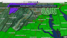
A flood watch remains in effect for some areas through Friday morning. Here is a full list of weather alerts.
Storm Team4 declared Thursday a weather alert day. Remember, never drive through a flooded roadway. Turn around, don't drown.
Rounds of rain, becoming heavy at times, will impact the day from start to finish. It will also be chilly with temperatures slowly warming into the mid-40s to mid-50s by the late afternoon and evening.
Steady rain through the day will become more intense this afternoon and evening, Storm Team4 Meteorologist Amelia Draper says. Expect the heaviest rain and higher chances for flooding tonight into Friday morning.
Local
Washington, D.C., Maryland and Virginia local news, events and information


Heavier rain will continue this evening and overnight into Friday morning.
In total, 1 to 3 inches of rain is likely by tomorrow morning. If this was falling as snow, totals would be up to 2.5 feet — but we're trending toward a winter with very little snow. The heaviest rain looks to set up around the I-95 corridor and locations south and east, where the flood watch is in effect.
The rain is expected to taper off after the Friday morning commute. Temperatures on Friday will fluctuate from the 40s and 50s in the morning and afternoon then drop into the 30s after sunset.
Wind chills Friday evening will be in the 30s with frigid wind chills Saturday morning in the 20s.
Stay with Storm Team4 and download the NBC Washington app to get weather alerts.