
WASHINGTON — Heavy rain is on the way to the region as the end of the work week approaches. This is good and bad news. The D.C. area needs the rain. But if the forecast holds, D.C. could make up the entire summer deficit of over 3 inches by Saturday (which just happens to be Oct. 1).
Wednesday and Thursday are Storm Team4 Weather Alert Days.
The set-up
An area of low pressure in the upper levels of the atmosphere is sitting over the Great Lakes on Tuesday night. By Wednesday, this low will break away from the mean flow/westerlies and meander down towards the Ohio Valley – setting up shop somewhere around Kentucky and Tennessee through Thursday night.
This upper low will eventually also cause a surface low to form along the stalled frontal system that passed through the region on Tuesday morning (that front brought rain Monday night into Tuesday morning). Moisture will be pulled into the area ahead of the low making for some ripe conditions for heavy rainfall. By Friday, the low will start to lift back towards the north taking the rain and clouds with it by Saturday afternoon.
Timing
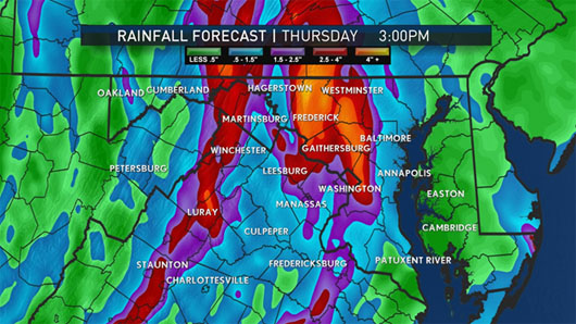
While there could be a few sprinkles on Wednesday morning during the morning commute, the bulk of the rain will move in from the south to the north from mid-morning through mid-afternoon. The area could see a few thunderstorms into the late Wednesday afternoon and evening. Rain will continue on Thursday, heavy at times with more showery activity expected for Friday. As the low begins to retreat north on Saturday, rain will start to end across the region from the south to the north.
Impacts
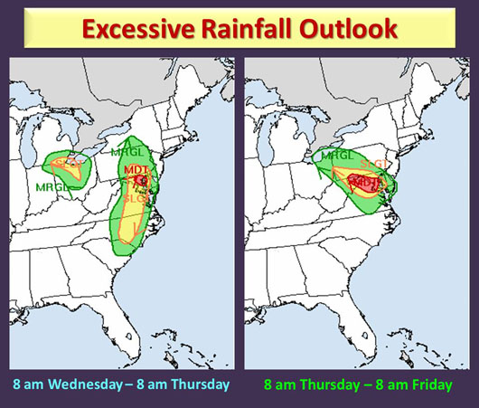
A flash flood watch has been issued for the region starting early Wednesday morning and continuing through Friday morning. Forecasters expect several inches of rain to accumulate in the region with anywhere from 2 to 4 inches.
Flash Flood Watch in effect tomorrow through Friday. Very heavy rain and possible flooding. Stay with us! pic.twitter.com/fRQ1gP72FN
— Doug Kammerer (@dougkammerer) September 27, 2016
The flash flooding threat will be high. This means flooding could happen in a matter of minutes from bands of very heavy rain that fall in a short amount of time.
Until then, just prepare yourself for a lot of rain to move into the region. It does seem that commutes will be affected, after school activities canceled and Nats games possibly postponed (or canceled). Stay tuned to WTOP for weather updates and remember, don’t attempt to drive into flood water: Turn around — don’t drown.
The post What you need to know about the heavy rain this week appeared first on WTOP.
