
WASHINGTON — More than 2 million people are being urged to evacuate along the southeastern coast of the United States as Hurricane Matthew, a possible hurricane for the record books, barrels in on Florida.
For the WTOP listening area, the effects will be pretty minimal. A trough of low pressure hangs off the Carolina coast with a lot of moisture forecast to surge up the coast from the hurricane. Rain showers and clouds will spread into the region for the second half of Friday as Matthew nudges north along the southeastern coastline. A frontal system will approach from the west, passing through the area on Saturday.
Expect clouds to increase on Friday, with rain showers possible as early as the afternoon in some portions of the area. Rain chances will continue overnight into Saturday — in fact, some showers could be moderate at times on Saturday. Once the front moves through by Saturday and into Sunday morning, winds will really pick up — they could gust up to 30 mph, or even more, at times, making for a cool and windy day around the mid-Atlantic.
Forecasters will continue to monitor the track of Hurricane Matthew, especially into the next workweek. The track after Sunday continues to be a little murky, but, again, the impact around the mid-Atlantic area will be minimal.
Related Gallery

IN THE SOUTHEAST, it’s a different matter.
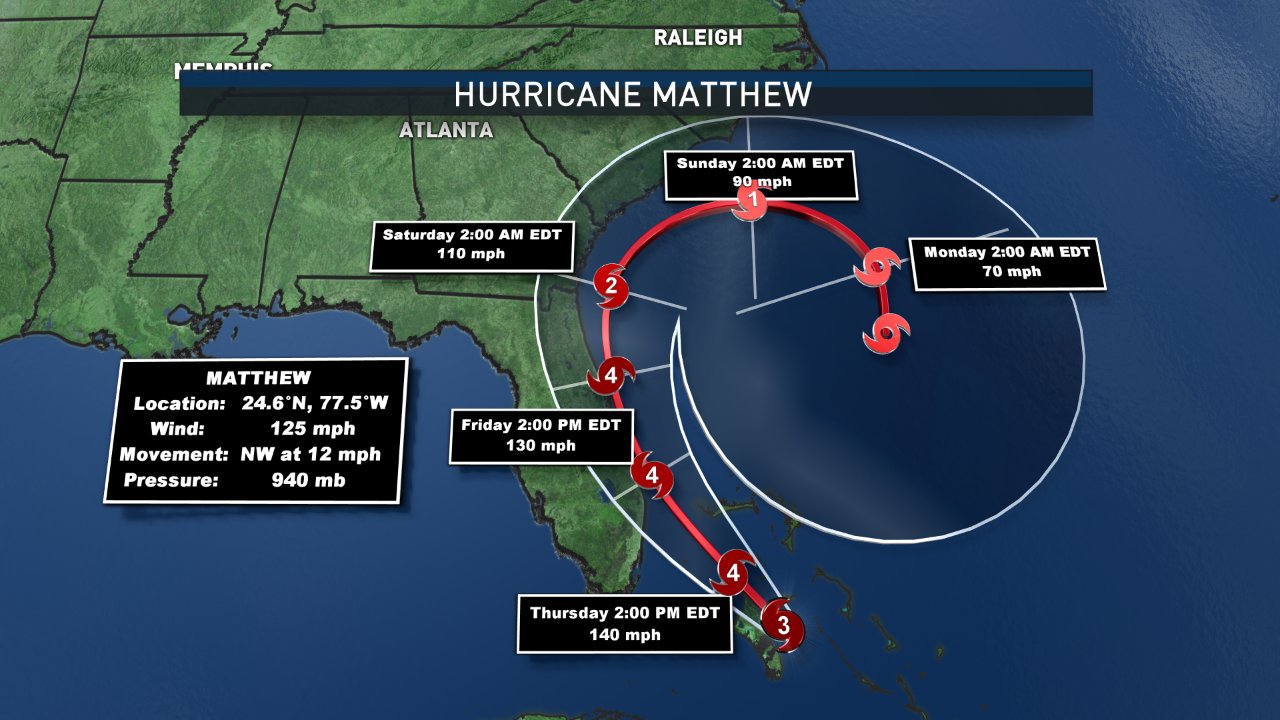
As of Thursday morning, winds are still around 125 mph, making Matthew a Category 3 hurricane. Matthew is strengthening slightly Thursday morning and will continue to intensify through the day, reaching Category 4 by the time it nears the Florida coastline later Thursday night and into Friday morning. Hurricane-force winds are extending outward to around 40 miles from the eye, with tropical storm-force winds extending around 160 miles from the center.
Unfortunately, conditions are ripe for the re-intensification of Matthew by the time it passes through the Bahamas. There is very warm water and very low wind shear, making strengthening of Matthew very likely before it heads to the Florida coastline.
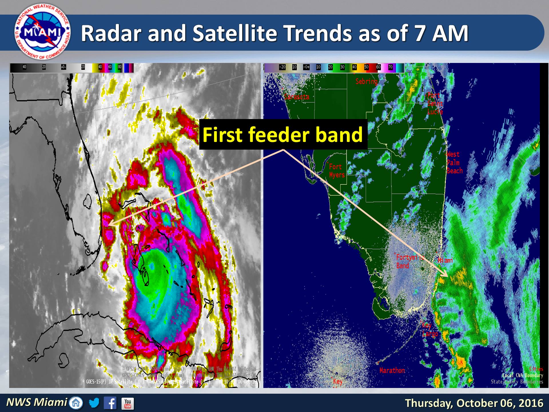
Hurricane warnings and watches are already in place along the southeast coastline. In fact, the first feeder bands bringing heavy rain and strong winds are already moving into portions of Miami.
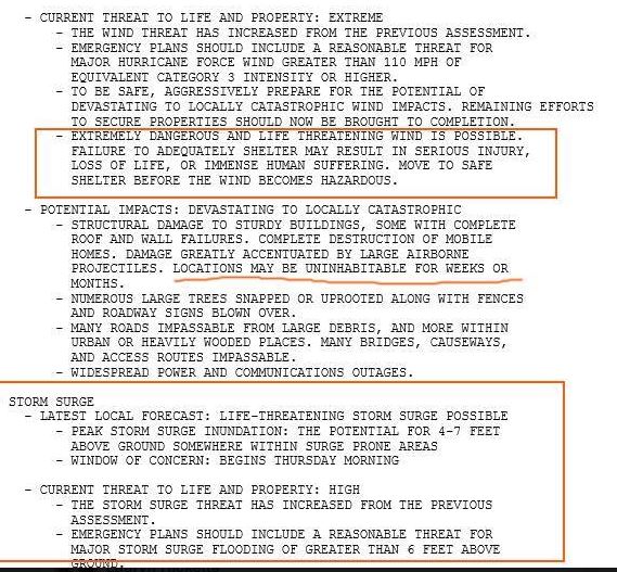
This is going to be a very dangerous hurricane with threats to life and property. In fact, Wednesday evening, the National Weather Service in Melbourne, Florida, issued a statement saying that a “life-threatening storm surge” was possible, and that some places “may be uninhabitable for weeks or months”:
As it continues to move up the southeastern coastline, from Florida to the coast of South Carolina, Matthew will start to make a curve to the east and back out to sea. It has been very interesting to see how the models have handled this track over the last couple days due to Tropical Storm Nicole. In fact, it looks as if the two tropical systems interact, making them almost dance with each other. This is fairly rare but has a name: The Fujiwhara effect. We will have to see how this plays out but it looks like a weaker Matthew could churn back south toward Florida by next week.
The post Hurricane Matthew’s impact minimal in DC area, ‘life-threatening’ in Southeast appeared first on WTOP.
