


What's left of Hurricane Ida is barreling toward the D.C. area as emergency crews prepare for heavy rain and floods.
Storm Ida, now a tropical depression after blowing ashore as a Category 4 hurricane, is on track to dump inches of rain in the D.C. area, sparking concern for flash floods. Rain accumulation of up to 6 inches is possible. There's also a risk of tornadoes.
Go here for the latest forecast on Wednesday.
The Federal Emergency Management Agency urged residents of the mid-Atlantic to prepare for “life-threatening flash, urban and river flooding” in the days ahead.
We're making it easier for you to find stories that matter with our new newsletter — The 4Front. Sign up here and get news that is important for you to your inbox.
D.C. is activating its Emergency Operations Center starting Wednesday, in an effort to coordinate the local, regional and federal response to the storm.
“We are asking residents to take Ida seriously and to pay close attention to the weather conditions and latest alerts,” Mayor Muriel Bowser said in a statement Tuesday afternoon.
The Maryland Emergency Management Agency urged residents to prepare for heavy rain, strong winds and possible tornadoes.
Virginia Gov. Ralph Northam declared a state of emergency Tuesday afternoon intended to aid the response to heavy rainfall and flooding expected in the southwest portion of the state. The emergency declaration does not apply to individuals or businesses, Northam's office said.
“I urge Virginians in these regions to stay alert,” the governor said in a statement. flagging the I-81 and I-66 corridors.
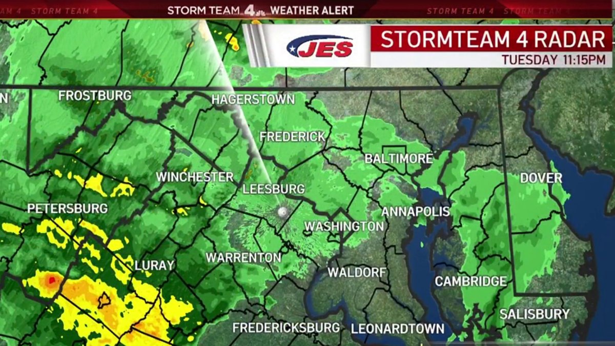
Track storm Ida's path toward the D.C. area on the radar above. Use the "layers" button to customize your view.
First responders at the Cabin John Park Volunteer Fire Department were preparing themselves on Tuesday for a rough day and many rescues due to flooding expected Wednesday.
The Montgomery County Fire & Rescue Service is staffing up and will have four extra swift water rescue boats on standby. Their No. 1 message Tuesday was this: Turn around. Don’t drown. If you’re driving and see standing water, don’t attempt to pass through it.
“Never drive into moving water, standing water. Never take the presumption that you’ve done it before, you can do it this time,” Chief Scott Goldstein said.
In Alexandria, the city passed out free sandbags. Some residents are still cleaning up from flooding two weeks ago.
Stay weather-ready. A flash flood watch will be in effect Tuesday evening to late Wednesday, the National Weather Service says. Here's a full list of weather alerts.
The following Virginia counties were under a tornado watch Tuesday until 3 a.m. Wednesday: Culpeper, Madison, Page, Rappahannock, Spotsylvania and Shenandoah.
Tuesday was the best chance to weather-proof property against flooding before the deluge arrives, Storm Team4 said. Clear gutters and storm drains, check any sump pumps and secure your basement plus any important or valuable stuff in it.
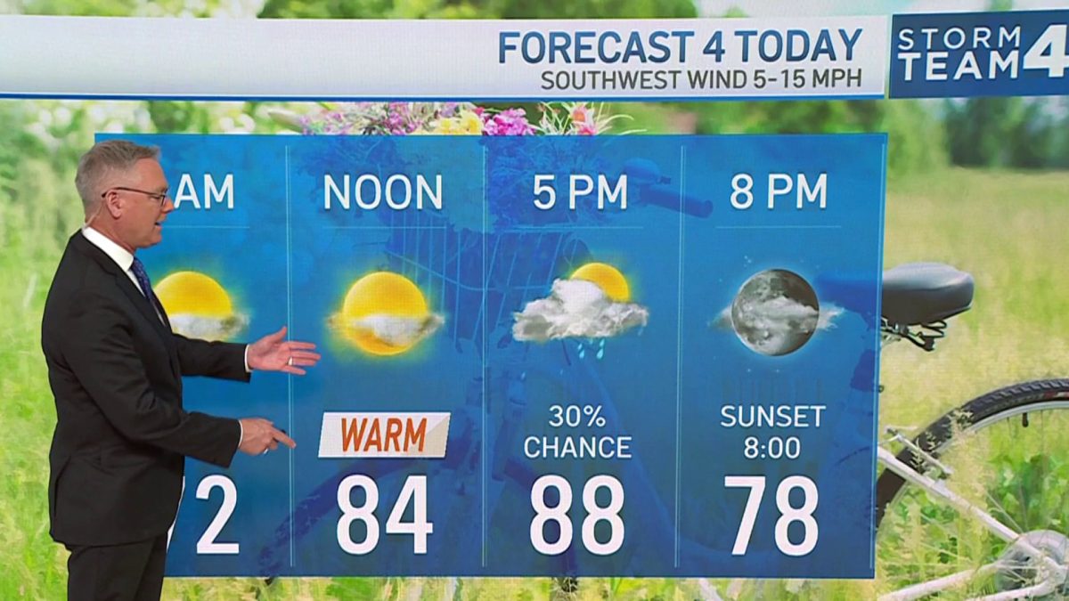
Here’s What Storm Team4 Says About the Timing
Keep an umbrella handy Tuesday: There’s a 40% chance of rain during the day amid temps in the 80s.
Through 1 a.m. Wednesday, we’re set to see rain at times, with pockets of heavier rain. Isolated damaging winds and tornadoes are possible.
From 1 a.m. to 9 a.m. Wednesday, the threat is lower, with rain at times. It’s set to be cloudy and humid through noon.
From noon to midnight Wednesday looks like a high-risk time, with rain, storms and high winds. Flooding is possible, especially north and west of D.C. A few tornadoes are possible, especially in the D.C. area and to the east. Wind gusts up to 50 mph are possible.


Thursday is expected to be breezy and nice, with low humidity and high temperatures in the low 80s. Waterways may still be flooded.
Friday will be sunny and spectacular, with high temps in the mid- to upper 70s.
Kicking off Labor Day weekend, Saturday will be mostly sunny too, with high temps in the mid-70s to low 80s. Sunday will be sunny and a bit humid, with a slight chance of scattered evening showers or storms. High temps will be around 80.
Remember: If you see high water, turn around, don't drown. Check out these links for flood preparation and safety tips from the National Weather Service and D.C.

