


According to a new report from NOAA, the U.S. coastline will see up to a foot of sea-level rise by 2050. NBC4’s Chief Meteorologist Doug Kammerer spoke to the National Park Service and NOAA about how this is already affecting the cherry blossoms in the tidal basin and plans to preserve the trees.
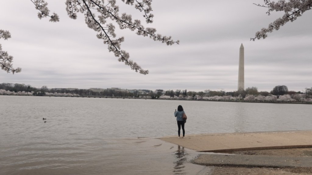
People have been enjoying the cherry blossoms down along the Tidal Basin for well over a century, but there's a new report out from the National Oceanic and Atmospheric Administration (NOAA) about sea level rise and the impact that it's going to have on those blossoms.
The cherry trees are in real trouble. Over the past 25 years, we've seen sea level rise of about three inches. That doesn't seem like a lot, but over the next 30 years, we're expecting sea level rise of nearly a foot.
"We should expect not only this extra foot of sea level rise, but more flooding," William Sweet, an oceanographer with the National Oceanic and Atmospheric Administration (NOAA), said.
It's flooding that we can already see around the Tidal Basin, in Old Town Alexandria and in Annapolis as well.
We're making it easier for you to find stories that matter with our new newsletter — The 4Front. Sign up here and get news that is important for you to your inbox.
"What used to be minor nuisance flooding now is going to become about a foot deeper, and happening at about a similar frequency," Sweet said.
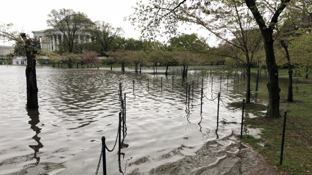
Before & After: Tidal Basin Flooding
Rising sea levels are leading to flooded walkways around the Tidal Basin.
Source: National Park Service
You can see the trees that are here are not doing particularly well. And in fact, you can see an open area where we had to remove 12 or 14 trees a few years ago.
Mike Litterst, National Park Service
Changing Climate
News4 is Working 4 You with in-depth coverage of our changing climate. Learn how it impacts your family, your money, your health and your commute.


Mike Litterst of the National Park Service says we can already see the trouble at high tide.
"Twice a day at high tide, the water comes up. It overlaps the walkway. We, in fact, moved the walkway a little further inland a number of years ago," Litterst said. "But even a couple of times a month, we will get tides high enough that even that rearranged path winds up under water a couple of times."
This is having a big effect on the cherry trees that ring the Tidal Basin.
"You can see the cherry trees that are so close to the shore, their root systems wind up going underwater twice a day. They're just not adapted for that kind of volume of water, the brackish water," Litterst said. "You can see the trees that are here are not doing particularly well. And in fact, you can see an open area where we had to remove 12 or 14 trees a few years ago."


Litterst said those trees' roots were damaged too badly by the constant inundation of water.
"When those trees were initially planted, we weren't having that kind of that kind of problem," Litterst said. "Again, we've got the rising, the rising levels of the Tidal Basin. It was compounded by the fact that we know that seawall around the Tidal Basin is sinking as well."
The vast majority of the trees were planted close to the shoreline. So most, if not all of them, will be impacted if we were to get a foot of sea level rise.
The benches are under water regularly. When I got here in 2014, that was a every couple or three or four months sort of thing. Now it's several times a week.
Mike Litterst, National Park Service
There are three main causes of sea level rise as we experience it in the Chesapeake Bay region, Sweet says.
"Two are global: Ice is melting on land in Antarctica and Greenland and mountain glaciers. And that's about two parts of the ocean rise signal. The other part is as the water warms, it expands," Sweet said. "That's the other part to the ocean rise signal. But what's important here in the Chesapeake for D.C., for Baltimore and Annapolis is land sinking, land sinking at a pretty high clip."
Those three factors together are contributing to the relative increases in the projections of expected sea level rise, Sweet said.

Litterst said this all has already led to big changes over the past several years.
"Even in the last few years, view down East Potomac Park, where you'll see we've had to to fence off considerable areas of the sidewalk," Litterst said.
"The benches are under water regularly," he said. "When I got here in 2014, that was an every couple or three or four months sort of thing. Now it's several times a week."
It all will have an even bigger impact in two or three decades, when sea level is a foot higher and the region gets a big storm.
"We're realistically looking at the possibility of the water reaching the Jefferson Memorial," Litterst said. "I mean, we're at the point now where even the walkway — not regularly, but several times a year — even the walkway will go underwater. Thirty years from now, if the levels rise at those levels, we can completely see where the water reaches the edge of the Jefferson Memorial."
While one foot might not seem like a lot, here at the Tidal Basin, it would really make an impact, making water about shin-deep for someone who's standing on the walkway today.
If you add the effect of high tide with a full moon, that could bring it upwards of two feet, possibly up to three.
If a hurricane were then making its way up the coast, water from that would also come in. That could add up to four, five or maybe even six feet, taking the water almost all the way to the base of the Jefferson Memorial.
So the future is now. We're flooding more often than we used to, and oftentimes with no storm in sight.
William Sweet, NOAA
"So the future is now. We're flooding more often than we used to, and oftentimes with no storm in sight," Sweet said. "To protect the things that are important to us as a community, as a society, our roads, our bridges are important places, are places of heritage."
Sweet said it's important to recognize the risks now.
"It's going to be hard to stem the flow of the tides; the tide's sort of going to go where the tides are going to go," he said. "But if we know how to live in and live around the tides and how to build according to the tides, there's there's hope; there's a future. "We'll be seeing the cherry blossoms in the Tidal Basin, I suspect, for many decades to come."
Washington, D.C.'s cherry trees are a beloved fixture of springtime. The National Cherry Blossom Festival every year brings a million and a half people every year to the Tidal Basin, Litterst said.
"One of the things that we're looking at is, how do we prepare for the future? How do we take care of it?" Litterst said. "The repairs to the seawalls here and in East Potomac Park is a priority for us. One of the things we're looking at as we start to make plans and designs is, how do we not just make it good for now, but how is it sustainable for the next 30, 40, 50, 100 years?"
Along the water, one tree has almost entirely been hollowed out. The roots are obviously damaged. But it was still managing to bloom.
"Here we are," Litterst said. "The green buds, starting to emerge."