Map: Look at the Drought Difference in California From One Year Ago
California is drought-free for the first time since December 2011 after a barrage of winter storms
By Jonathan Lloyd ••
Storms continued to pile on snowpack and fill California's water reservoirs over the past week, pulling even more of the state out of drought.
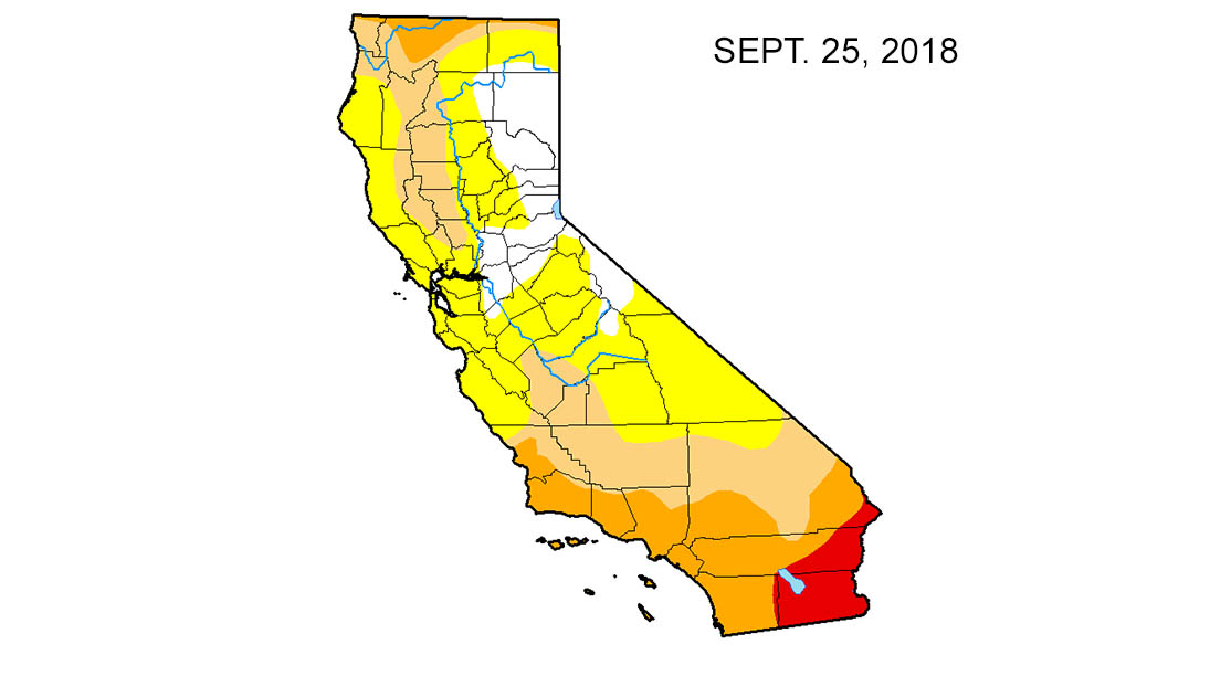
Last week, a small sliver of extreme Northern California was the only part of the state in moderate drought. That area and a swath of California near its border with Mexico were listed as abnormally dry, a less severe condition than drought, in this week's U.S. Drought Monitor report.
That means California is free of drought for the first time since Dec. 20, 2011, according to the National Drought Mitigation Center.
US Drought Monitor
This map shows drought conditions at the start of the water year, the wettest months of the year, in September 2018 in California.
One year ago, nearly 50 percent of California was in moderate to extreme drought. Part of Ventura County and a northwest Los Angeles County were in the extreme drought category -- the second-most severe category in the drought monitor's ranking system -- at this time last year.
Just three months ago, 75 percent of the state was in moderate to extreme drought.
Even the Salton Sea area, a southeastern California region that has consistently been among the driest parts of the state, returned to what the Monitor described as normal conditions.
"The rest of the region in Southern California is still abnormally dry due to very dry previous years," the weekly report noted. "Reservoirs in San Diego County are only at 65 percent capacity."
California Department of Water Resources
The results of California's annual snowpack surveys in the Sierra Nevada Mountains have been mixed over the decades.
NBC10 Boston
The California Department of Water Resources conducts a snow survey to measure the snowpack in the Sierras in El Dorado County in Northern California. Photo taken sometime during 1958.
California Department of Water Resources
California Department of Water Resources snow survey team right, Ray Barsch and Christopher Carr cross country ski to the Alpha test site, 7600 feet elevation in the Sierra Nevada mountain range near Forni Ridge and Lyons Creek in El Dorado County north of U.S. Highway 50. The water runoff from this area is part of the American River Watershed in Northern California. Photo taken April 11, 1967. Paul Weber / California Department of Water Resources, FOR EDITORIAL USE ONLY
California Department of Water Resources
Center, Frank Gehrke, chief of the California Cooperative Snow Surveys Program for the Department of Water Resources prepares for the monthly snow survey at Phillips Station in El Dorado County in the Sierra Nevada mountains. Photo taken March 2, 2009.
Telemundo
Right, Frank Gehrke, chief of the California Cooperative Snow Surveys Program for the Department of Water Resources leads the way to conducts the monthly snow survey during a snow storm at Phillips Station in El Dorado County in the Sierra Nevada mountains. Photo taken March 3, 2010.
Kelly Grow / California Department of Water Resources
Frank Gehrke conducts California Department of Water Resources monthly snow survey at Phillips Station near Echo Summit on December 30th, 2014.
California Department of Water Resources
The mountains at Phillips Station near Echo Summit on January 3, 2014.
CADWR
Frank Gehrke (DWR Chief of Snow Surveys) addresses the media during a snow survey at Phillips Station on April 1, 2015. The black tag on the pole is where the snow was in the drought year of 1977, the yellow tag is where the snow was the year before, and the green tag is where the snow is on an average year.
The Department of Water Resources (DWR) conducts a snow survey at Phillips Station on April 1, 2015. Measurements in Phillips began in 1942, and this report marked the first time there was zero snow for an April 1 measurement. Below-normal precipitation, combined with unusually warm weather, produced meager snowfall during the traditional wet season.
California Department of Water Resources
Right, Frank Gehrke, chief of the California Cooperative Snow Surveys Program for the Department of Water Resources, conducts the monthly snow survey at Philips Station.
California Department of Water Resources
Members of the California Council on Science and Technology Science Policy Fellows left to right, Michael Peterson, Julianne McCall and Mikel Shybut assist Frank Gehrke Chief of the California Cooperative Snow Surveys Program with the second snow survey of the 2017 snow season at Phillips Station in the Sierra Nevada Mountains. The survey site is approximately 90 miles east of Sacramento off Highway 50 in El Dorado County. Photo taken February 2, 2017.
Dale Kolke / California Department of Water Resources
The third snow survey of the 2017 snow season at Phillips Station in the Sierra Nevada Mountains. The survey site is approximately 90 miles east of Sacramento off Highway 50 in El Dorado County. Photo taken March 1, 2017.
California Department of Water Resources
A snow-covered Sierra Nevada mountain peak to the northwest from the Phillips Station meadow where the California Department of Water Resources conducted its third snow survey of the winter 2017 season. Photo taken March 1, 2017.
California DWR
A view of the Phillips Station site on Jan. 3, 2018 before the first snow survey of the season.
California DWR
A view of Phillips Station in the Sierra Nevada Mountain Feb. 1, 2018 during the second snowpack survey of the year.
CA DWR
A view of Phillips Station in the Sierra Nevada Mountains ahead of the third manual snow survey of 2018. The same meadow had just 7 percent of its usual snowfall a couple of weeks ago. A big winter storm a week earlier brought that up to 39 percent.
California Department of Water Resources
Frank Gehrke, Chief of the California Cooperative Snow Surveys Program leads the way to conduct the fourth snow survey of 2018 at Phillips Station in the Sierra Nevada Mountains. The survey site is approximately 90 miles east of Sacramento off Highway 50 in El Dorado County. Photo taken April 2, 2018.
California Department of Water Resources
John King, Water Resource Engineer, of the California Department of Water Resources, prepares to insert the long aluminum snow depth survey pole into the snow for the third media snow survey of the 2019 season at Phillips Station in the Sierra Nevada Mountains. The manual survey recorded 113 inches of snow depth and a snow water equivalent of 43.5 inches -- more than double the previous month.
California Department of Water Resources
John King, Water Resource Engineer, DWR Snow Survey Section, leads the fourth snow survey of water year, followed by team of members of DWR's excecutive staff. The survey showed snow water equivalent at 200 percent of average for the site.
California DWR
The third snow survey of the season is conducted March 2, 2021.
California DWR
California’s Jan. 3, 2023 snow survey in the Sierra Nevada Mountains.
Big Bear Lake in the mountains east of Los Angeles was down 18 feet in early March, but it's expected to continue to rise, according to the report.
Also in Southern California, Lake Piru in Ventura County is at 74 precent capacity, Cachuma Reservoir in Santa Barbara County is at 73 percent capacity, and Lake Casitas near Ventura is up to 43 percent capacity.
One of the most encouraging signs is the giant pillow of snow covering the Sierra Nevada Mountains. A manual survey of snowpack at Phillips Station late last month indicated a snow depth of 113 inches and a snow water equivalent of 43.5 inches.
Getty
Some of the sights you'll see at California's evaporating Salton Sea in the extreme southwest part of the state.
Getty Images
A bridge near Red Hill Marina stands on ground dried by evaporation on June 30 near Calipatria, California, southeast of the Salton Sea.
Getty Images
Foundations of buildings of an early 20th century resort that was used before the rising waters of the Salton Sea turned this hill into Mullet Island, one of the four Salton Buttes, small volcanoes on the southern San Andreas Fault.
Getty Images
Steam rises from thermal vents that, until recently, were underwater on the floor of the Salton Sea.
Getty Images
Small mud volcanoes grow above the southern San Andreas Fault near the Salton Sea near Calipatria, California.
Getty Images
Buildings of an apparent hot mineral spring spa on a mud flat in the thermal fields of the southern San Andreas Fault at the Salton Sea have fallen down.
AP
Biologist Tom Anderson of the Sonny Bono Salton Sea National Refuge Complex steers an airboat across the shallow waters of the Salton Sea.
Getty Images
Foundations of buildings of an early 20th century resort that was used before the rising waters of the Salton Sea turned this hill into Mullet Island, one of the four Salton Buttes, small volcanoes on the southern San Andreas Fault.
AP
This May 1, 2015 aerial file photo shows the exposed lake bed of the Salton Sea evaporating near Niland, Calif. California officials have proposed spending nearly $400 million over 10 years to slow the shrinkage of the state's largest lake. Gov. Jerry Brown's administration on Thursday, March 16, 2017 unveiled a plan to build ponds on the northern and southern ends of the Salton Sea. It's expected to evaporate at an accelerated pace starting next year when the San Diego region no longer diverts water to the desert region. (AP Photo/Gregory Bull, File)
Getty Images
Steam rises from thermal vents that, until recently, were underwater on the floor of the Salton Sea.
AP
Oxygen-starved tilapia float in a shallow Salton Sea bay. Often called the "The Accidental Sea," because it was created when the Colorado River breached a dike in 1905.
AP
Steam rises from geothermal mud pots near the banks of the Salton Sea near Niland, California, evidence of the region's vast geothermal activity.
AP
Sunlight reflects off irrigated fields near Mesquite, California.
AP
In this April 29, 2015, photo, farmer Al Kalin walks back to his truck on his farm near Westmorland, Calif. Kalin, who farms 1,800 acres near the Salton Seas's southern shores, installed sprinklers and other water saving measures to replace flood irrigation over the last five years.
AP
An abandoned motel sits on the edge on of the Salton Sea in late 2006. The Salton Sea, California's largest lake, was created in 1905 when floodwaters from the Colorado River burst past a series of dams.
AP
Palm trees destroyed in earlier flooding line the banks of the Salton Sea.
AP
A dead tilapia floats among algae in a shallow Salton Sea bay near Niland, California.
AP
Bruce Wilcox of the Imperial Irrigation District speaks in front of cracked, exposed Salton Sea lakebed.
AP
Irrigated citrus trees sit surrounded by bone-dry land near Westmorland, California. The Imperial Valley's half-million acres of verdant fields end abruptly in pale dirt that gets three inches of rain annually on average.
AP
Biologist Tom Anderson makes a call along the receding banks of the Salton Sea.
AP
Biologist Tom Anderson steers an airboat across the shallow waters of the Salton Sea, often called the "The Accidental Sea."
AP
Ed Victoria sits under an umbrella as he fishes for tilapia along the receding banks of the Salton Sea near Bombay Beach, California.
Getty Images
Mud boils violently in steam vents that, until recently, were underwater on the floor of the Salton Sea.
Getty Images
A road sign that was once flooded by the rising Salton Sea stands on ground dried by evaporation on June 30 near Calipatria, California.
Getty Images
A road sign that was once flooded by the rising Salton Sea stands on ground dried by evaporation on June 30 near Calipatria, California.
Getty Images
Outhouses and an old lifeguard stand are stored on Red Hill, one of the four Salton Buttes, small volcanoes on the southern San Andreas Fault at the Salton Sea.
Getty Images
An area of rock quarry activity is seen on Red Hill, one of the four Salton Buttes, small volcanoes on the southern San Andreas Fault at the Salton Sea.
Getty Images
Rock Hill, one of the four Salton Buttes, small volcanoes on the southern San Andreas Fault, and a geothermal energy plant are seen at the edge of the Salton Sea.
Telemundo San Antonio
A bullet-and shotgun pellet-riddled boat is seen abandoned near Travertine Point on March 21, 2012 south of Mecca, California.
Getty Images
Years of accumulated garbage dumped in the desert is seen next to a native Palo Verde tree near Travertine Point on the northwest shore of the biggest lake in California, the Salton Sea.
Getty Images
Date palms are seen on the northwest shore of the Salton Sea in Mecca, California.
Getty Images
Disused structures on the shore of the Salton Sea.
Getty Images, File
Pelicans fly over a great blue heron on the shore of the Salton Sea.
Getty Images
The northwest shore of the biggest lake in California, the Salton Sea, on March 20, 2012 south of Mecca, California.
That's double what was recorded a month before at the same location.
Statewide, the Sierra snowpack was at 153 percent of average for the late February survey. The snowpack is a critical part of California's water supply because that snow melts in spring and runs off into the state's water system.
CA DWR
Right, a serpentine stretch of the California Aqueduct in Palmdale, Calif. within Los Angeles County at mile post 327.50. Photo taken February 7, 2014. Left, part of the Sierra Nevada Mountains.
California Department of Water Resources
Before we get to the California Aqueduct, here's where California's water lifeline starts -- a snow-covered Sierra Nevada mountain peak. This view is to the northwest from the Phillips Station meadow where the California Department of Water Resources conducted its third snow survey of the winter 2017 season. Photo taken March 1, 2017.
AP
Here's a look at conditions in the Sierra Nevada, Thursday, March 30, 2017, near Echo Summit, Calif. The location is where the California Department of Water Resources holds its manual snow survey at nearby Phillips Station. In late March 2017, the water content was at 183 percent of normal.
AP
The snowpack is so important, California water resources managers keep a close eye on it. Frank Gehrke, right, chief of the California Cooperative Snow Surveys Program for the Department of Water Resources, lifts the survey tube out of the snowpack depth during the manual snow survey at Phillips Station, Thursday, March 30, 2017.
AP
Water from snowmelt cascades down the South Fork of the American River on May 1, 2017, near Echo Summit. The warming springtime temperatures in California melt the state's snowpack, sending water into rivers and streams from the Sierra Nevada Mountains. (AP Photo/Rich Pedroncelli)
California Department of Water Resources
When the mountain snow melts, it runs downhill in rivers and stream, eventually ending up in the State Water Project. This view is looking north from the California Aqueduct Vista Point, an exit off the southbound 5 Freeway near Exit 423/Stuhr Road in Stanislaus County west of the Sierra Nevada range. Photo taken March 4, 2013.
California Department of Water R
Another view looking north from the California Aqueduct Vista Point in Stanislaus County. This photo was taken July 23, 2015, two years after the previous image during California's recent dry spell.
Paul Hames / California Department of Water Resources
This is an aerial view of the California Aqueduct near Tracy, California. It is the location of a 108-inch diameter interconnect pipeline in the ground between the California Aqueduct, to the left, and the Delta-Mendota Canal, which is part of the Central Valley Project. Photo taken April 20, 2012.
California Department of Water R
Another aerial view of the "intertie" constructed between the Delta-Mendota Canal and the California Aqueduct near Tracy. Photo taken April 20, 2012. Paul Hames / The California Department of Water Resources
John Chacon / California Department of Water Resources
The California Aqueduct is pictured in Alameda County, just north of the Bethany Reservoir.
California Department of Water R
As we head south, the California Aqueduct runs through the brown, dry hills of Newman in July 2015.
California Department of Water Resources
A pastel sky over the California Aqueduct in the San Joaquin Valley. Photo taken April 10, 2014.
AP
This undated file photo released by the California Department of Water Resources shows water making its way south through the Central Valley by way of the California Aqueduct.
Getty Images
Part of the east branch of the California Aqueduct, which imports water from the Sierra Nevada Mountains.
Getty Images
The California Aqueduct passes through the Dos Amigos pumping plant on April 24, 2015 in Los Banos, California.
California Department of Water R
The California Aqueduct near Highway 166 south of Bakersfield. Photo taken December 13, 2012. Florence Low / California Department of Water Resources
California Department of Water Resources
In Kern County, the California Aqueduct is seen at sunset.
John Chacon / California Department of Water Resources
This moonlight view is looking south toward the Tehachapi Mountains in Kern County.
John Chacon / California Department of Water Resources
Twilight falls over Kern County and the California Aqueduct.
California Department of Water R
The California Aqueduct splits into the West Branch and East Branch as it travels into the Southern California region.
California Department of Water Resources
The California Aqueduct bifurcates in the West Branch and East Branch as it travels into the Southern California region at the border of Kern and Los Angeles Counties. Photo taken February 6, 2014.
Florence Low / California Department of Water Resources
Another view of the California Aqueduct as it separates into the East Branch (left) and West Branch (right). Photo taken February 6, 2014.
California Department of Water Resources
The California Aqueduct just north of the A.D. Edmonston Pumping Plant looking west. Photo taken 1992. Dale Kolke / California Department of Water Resources
Florence Low / California Department of Water Resources
Another stretch of the California Aqueduct East Branch in Palmdale. Photo taken on February 7, 2014.
California Department of Water R
Another view of the winding stretch of the California Aqueduct in Palmdale. Photo taken February 7, 2014.
Getty Images
The California Aqueduct carries water from the Sierra Nevada Mountains through the high desert communities north of Los Angeles.
Getty Images
The California Aqueduct carries water from the Sierra Nevada Mountains to southern California. A segment the aqueduct is pictured in May 2008 near Palmdale.
Getty Images
The California Aqueduct carries water from the Sierra Nevada Mountains to Southern California. This picture is near Palmdale in May 2008.
Getty Images
The California Aqueduct carries water from the Sierra Nevada Mountains in May 2008 through Palmdale to other parts of Southern California.
California Department of Water R
This stunning aerial image shows a serpentine stretch of the California Aqueduct in Palmdale. Photos taken on February 7, 2014. Florence Low / California Department of Water Resources, FOR EDITORIAL USE ONLY
CA Department of Water Resources
This aerial view looks north toward Pyramid Dam and Pyramid Lake located on Piru Creek in Los Angeles County. The reservoir provides emergency storage for deliveries from the West Branch Aqueduct. It's also a popular recreational site for Southern Californians. Photo taken May 9, 2014.
John Chacon / California Department of Water Resources
A warning sign along the California Aqueduct East Branch. This location is where Highway 138 crosses the Aqueduct near the community of Neenach in Los Angeles County. Photo taken April 25, 2013.
Getty Images
Another view of the Los Angeles Aqueduct, which carries water from the snowcapped Sierra Nevada Mountains to the Los Angeles area.
Getty Images
Separate from the California Aqueduct network is the the Los Angeles Aqueduct, built and maintained by the the LADWP. Unlike most of the water collected from the Sierras, the LA Aqueduct receives its water from runoff on the eastern side of the mountains. Here, it is seen with snowcapped Sierra Nevada Mountains in the background, carrying watter to major urban areas of southern California on May 9, 2008 near Lone Pine.
“As the climate continues to warm, atmospheric rivers, responsible for many of the heaviest extremes, will carry more moisture and extreme precipitation may increase,” the assessment says.
Atmospheric rivers, bands of moisture in the sky over the Pacific that fuel colossal rain-making storms, have contributed to some of California's wettest winters. Storms draw moisture from the rivers as they move toward California, sometimes unleashing days of steady rain on the West Coast.
But warming air can also exacerbate periods of drought.
One group of researchers last year dubbed the change from extreme dry to wet conditions in the state as “precipitation whiplash events,” Quartz reported.
In 2014, then-Gov. Jerry Brown declared a drought emergency for California, ordering prohibitions on wasteful water use like hosing off driveways and sidewalks, and watering lawns within days of a rainstorm, after a several dry years. That emergency order was lifted for most of the state in 2017 after a historically wet winter.