
Storm Team4 is tracking a storm on Saturday that could generate some of our last snowflakes of the season.
As we transition to spring, the next few days will bring weather all over the map.
On Wednesday, rain is washing over the region. After a wet morning commute, expect continuing showers and temperatures around 40°.
Most of the rain should be done by 6 or 7 p.m., Storm Team4 says.
We're making it easier for you to find stories that matter with our new newsletter — The 4Front. Sign up here and get news that is important for you to your inbox.
Some snow has been spotted north and west of D.C. and in high-elevation areas. A winter weather advisory was issued for parts of the Blue Ridge, but don’t expect snowflakes closer to D.C. — yet.
Thursday will have more clouds with highs near 50°.
Friday would be a nice day to enjoy lunch outside with sun in the morning and highs near 60°.
Weather
Latest weather forecast, live radar and weather maps for Washington, D.C., Maryland and Virginia

Storm Expected Saturday in DC Area
A powerful and fast-moving storm will impact the area on Saturday. You may see some snowflakes, but not enough to cause significant travel problems.
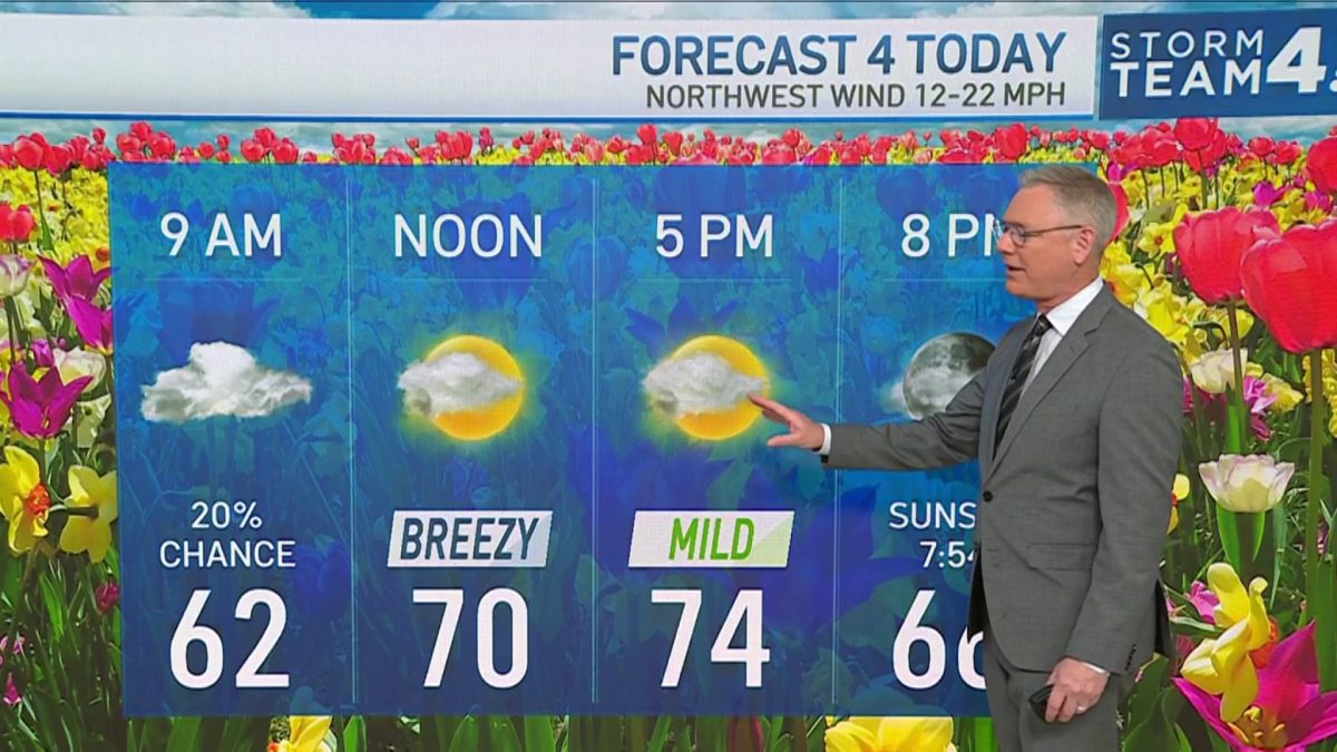
After a mild start, a cold front will usher in chilly air and a howling northwest wind, Storm Team4 says.
There is a 100% chance of rain and a high chance that it will be a transition to snow during the afternoon. No snow accumulation is expected.
Wind gusts over 40 mph will be likely from around 11 a.m. through sunset.
Temperatures will also fall rapidly throughout the day, from the mid-40s by 9 a.m. to the mid-30s by 5 p.m. to below freezing by 8 p.m. Evening wind chills may drop into the 10s — it will be a good night to get cozy on the couch.
A refreeze is possible late Saturday due to the cold. Roads could be slippery or have icy spots.
Sunday will be cold with highs in the low to mid-40s, but it will be sunny.
Next week, we’ll have east, dry and mild weather. Expect highs around 60 on Monday and Tuesday, then warmer air on Wednesday, Thursday and Friday.
