Storm Team4 Meteorologist Chuck Bell has the forecast for Jan. 25, 2021.
Update: This article is no longer being updated as of Monday, Jan. 25, 2021 at 6 a.m. Please go here for the latest.
We haven't seen much wintry weather this month, but it could be returning later Monday afternoon and into Tuesday morning
If you need to commute on Monday, the morning rush hour is set to be dry. Then “get where you need to go and stay there,” Storm Team4 Lauryn Ricketts said.
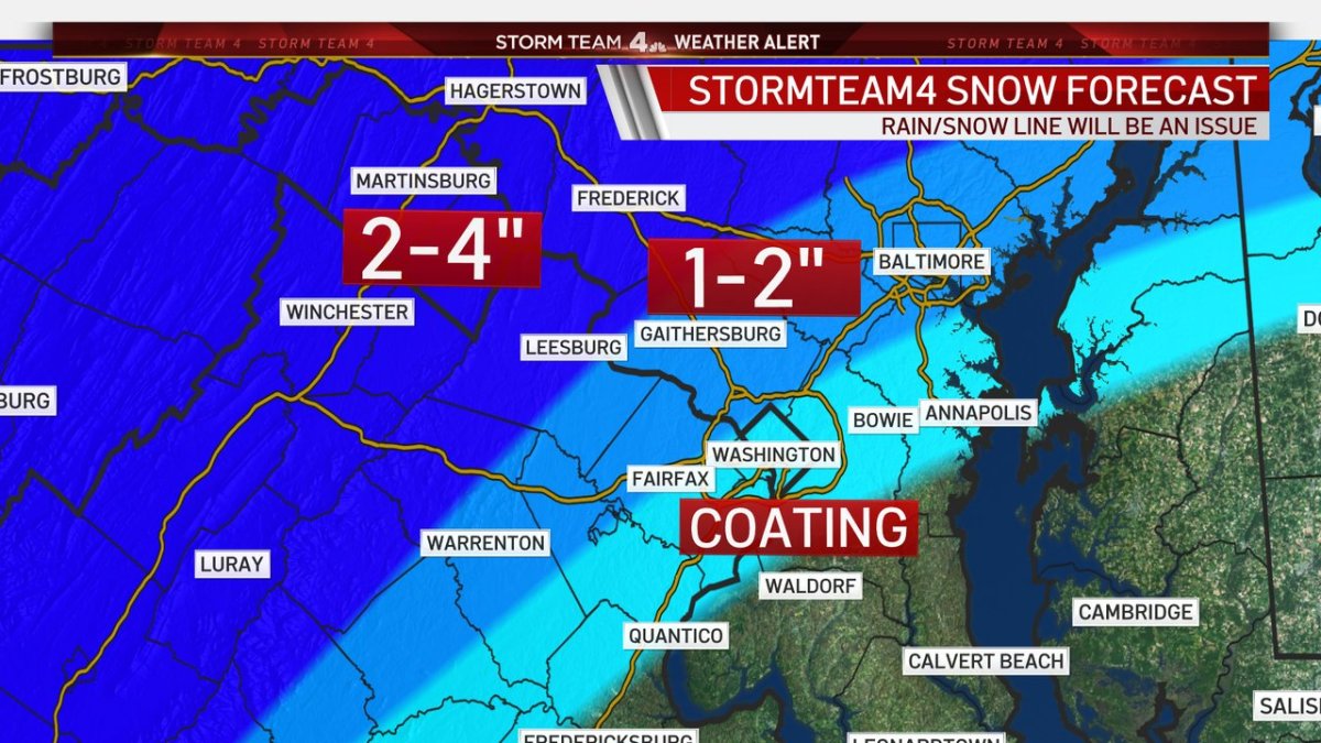
Rain late Monday afternoon will change to snow, accumulate a bit and then change again to a mix of sleet or ice. The areas expected to see the biggest impacts are upper Montgomery and Frederick counties and west of Dulles International Airport into the Shenandoah Valley.
Storm Team4 has declared a Weather Alert for both Monday and Tuesday.
Not everyone in the region will get impactful winter weather. As is so often the case, areas north and west of D.C. are more likely to see snow, sleet or ice.
The District, the immediate suburbs and areas south toward Fredericksburg and east toward the Chesapeake Bay will get almost entirely rain.
Local
Washington, D.C., Maryland and Virginia local news, events and information
A winter weather advisory is in effect for Montgomery, Howard and Frederick counties in Maryland, as well as the Interstate 81 corridor. (Go here to see all severe weather alerts from the National Weather Service.) In these areas, precipitation will likely start as rain Monday afternoon and then undergo a change to mixed precipitation after dark. Total amounts of rain will be in the 1/2" to 3/4" range. In the advisory areas, the changeover could lead to as much as a slushy inch or two of snow between sunset and midnight.
The later into the night it gets, the more warm air will be brought into the storm. This will lead to snow changing to sleet and eventually back to all rain before finally ending around noon Tuesday.
One more thing to keep in mind is that any sheltered valleys, where the cold air will be trapped the longest, could experience six to eight hours of freezing rain. Upper Montgomery and Frederick counties would be most at risk for this icing, as well as the deepest parts of the Shenandoah Valley and upper Loudoun County.
The whole mess will end Tuesday afternoon, but this cold and wet pattern is here a while longer: Wednesday looks cloudy and cold, and our next winter weather concern will arrive Wednesday night into Thursday.
This second storm is more likely to be snow than the mixed-bag event we will deal with Monday night. That said, there are real challenges with how much snow there will end up falling. Nothing is in favor of a blockbuster event at this time. The Wednesday-into-Thursday event will most likely end up as a nuisance with 2-4", but stay tuned for many more updates.
Stay with NBC Washington and Storm Team4 for updates.