
Extreme heat is keeping a grip on the Washington, D.C., region, and a tropical storm watch has been issued in parts of Southern Maryland as forecasters track storm Elsa's path up the East Coast.
Calvert County and St. Mary's City are under a tropical storm watch, which means storm-force winds are possible within 48 hours, the National Weather Service says.
A flash flood watch will also take effect for parts of Maryland and Northern Virginia from Thursday afternoon through Friday morning.
Here's a full list of severe weather alerts.
We're making it easier for you to find stories that matter with our new newsletter — The 4Front. Sign up here and get news that is important for you to your inbox.
Downpours could cause moderate flooding, and winds could gust up to 57 mph.
Damage to porches, awnings and mobile homes is a risk; trees could be broken or uprooted and scattered power outages may occur, the National Weather Service says.
Before Elsa has a noticeable impact on the D.C. metro area, expect dangerously high heat.
D.C.’s summer swelter persisted Wednesday, and the heat index climbed to near 100° again. High temperatures reached about 95° in the afternoon, but with the humidity, it was feeling even hotter.
Some isolated storms are possible during the afternoon, but mainly to the west.
Stay safe by drinking extra water; watch out for kids on sun-baked playground equipment and keep pets' paws off the hot pavement.
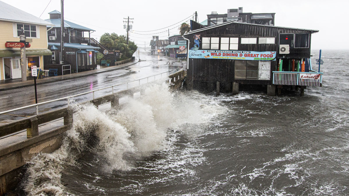
Tropical Storm Elsa is churning around Florida. Storm Team4 will be tracking local impacts from Elsa beginning Thursday.
The worst impacts are expected south and east of D.C., including in parts of Southern Maryland, Virginia Beach and coastal Delaware. But the D.C. metro area could get strong to severe storms.
Be prepared for stormy weather on Thursday evening, then overnight and into Friday morning.
Early Friday, rain from the remnants of Elsa will move out. Then, skies will turn partly sunny although more spotty rain is possible.
Saturday is set to be less humid and partly sunny and chances for rain or storms are falling.
Sunday has a higher chance for rain amid mostly cloudy skies and temps in the upper 80s.
Heat Safety Tips & Cooling Centers
When the temperature or heat index in the District is forecast to be 95° or higher, D.C.'s government implements its Heat Emergency Plan and activates cooling centers for residents to seek relief from the heat. You can find a list of D.C. cooling center locations at heat.dc.gov.
"Extreme heat is dangerous and can cause illnesses and death. As temperatures rise, you are encouraged to take an active role in your safety and take action to stay cool," D.C. officials warn.
They share these tips to stay safe and help protect others:
- Stay indoors: Find places in the shade or with air conditioning to seek relief from the heat.
- Check on your neighbors: Young children, senior citizens and those with access and functional needs are the most vulnerable.
- If you or someone you know needs transportation to a cooling center, call the shelter hotline at 202-399-7093.
- Drink plenty of water and wear lightweight, loose-fitting clothing.
- Do not leave children or pets in vehicles. Vehicles can reach dangerous temperatures within 10 minutes.
- For all animal emergencies, including animals left outside in extreme temperatures or in vehicles, call the Humane Rescue Alliance at 202-723-5730.
- Keep pets indoors, walk them early in the morning, and give them plenty of water.
- For additional tips on extreme heat, visit ready.dc.gov/extremeheat
