
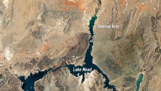
New satellite images released by NASA show the devastating water loss at Lake Mead, the country's largest reservoir and the source of water for tens of millions in the west.
The water levels are now at their lowest since 1937, when the lake that straddles Nevada and Arizona was still being filled for the first time, according to NASA.
The images, taken 22 years apart, show the staggering impact climate change has had since 2000, when the first image was captured by NASA's Landsat 7. The second was taken by Landsat 8 in early July.
We're making it easier for you to find stories that matter with our new newsletter — The 4Front. Sign up here and get news that is important for you to your inbox.
Who Gets Water From Lake Mead?
Water from the reservoir supplies communities in California, Nevada, Arizona and parts of Mexico.
The lake is primarily maintained from snowmelt from Colorado and Wyoming. As megadrought conditions have continued to grip the western states for more than a decade, lower-than-average snowpacks have provided less water to fill the reservoir.
U.S. & World
The day's top national and international news.


Drought restrictions have been implemented in many southwestern cities, including Los Angeles and Las Vegas.
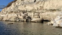
What Does Lake Mead Look Like Now?
As the water levels have continued to drop, the lake has been the subject of fascination, with a World War II-era sunken boat being revealed in June.
The lake's ties to nearby Las Vegas mob lore have also resurfaced, with bodies being found in the now-dry areas.
The Southern Nevada Water Authority announced in late April that the lake had shrunk so much that it had begun pumping from areas other states don't have access to in order to keep Las Vegas going.
The authority's Low Lake Level Pumping Station is operational, and it released photos of the uppermost intake visible at 1,050 feet above sea level at the lake behind Hoover Dam.
The Associated Press contributed to this report.
