
WASHINGTON — Heavy rain and a few storms will make their way through the region Monday evening, with the potential for damaging winds and hail.
A strong upper level low is moving to the Great Lakes area pulling a pretty powerful cold front with it to the east. This front will pass through the D.C. region late Monday night and into the overnight. Ahead of the front, some strong storms are developing and moving into portions of the region.
While I am not expecting a widespread severe outbreak, if you have plans this evening, make sure you have access to a strong umbrella — one that can withstand winds because chances are that you may need it.
Rain will continue to track to the east at a pretty quick speed. Expect a chance of rain and storms from 5 p.m. through late Monday night. Considering the sunshine that we experienced Monday and temperatures shooting into the 80s in most spots with added humidity, we have a decent amount of instability in a lot of the region. That will give way to increased chances of severe weather in our area — especially to areas north and west of D.C.
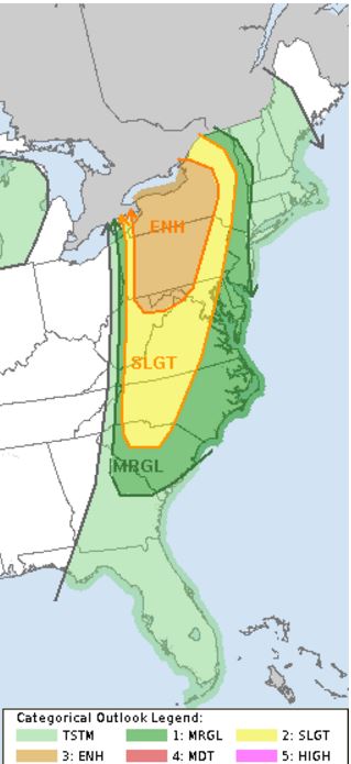
The Storm Prediction Center has placed a lot of the region in a “slight risk” area for severe weather, meaning that scattered severe storms are possible. Winchester, Virginia, the Eastern Panhandle of West Virginia and areas along I-81 north through Pennsylvania area in an “enhanced risk” for severe weather, meaning that numerous severe storms are possible through the evening.
We will really have to watch how these storms develop once they cross over the mountain ranges, but again, the best chance of severe weather lies north and west of D.C. Any storms that continue to track east of the Blue Ridge Mountains could still become severe however; they just won’t be as widespread.
Heavy downpours, strong winds and even some small hail possible within any of the storms the move into the area. The severe threat will end by about 10 p.m. Monday night with a chance of some storms continuing into the early portion of the overnight.
By Tuesday, we will begin drying out as humidity levels drop. Winds will pick up and it will be a comfortable but windy day. More rain is expected on Thursday into Friday so if you don’t get your rain fix tonight, I definitely believe everybody will have equal chances for some heavy rain Thursday into Friday.
Visit our weather page for the latest updates, follow us on Twitter @WTOP, and listen to live weather reports every 10 minutes on 103.5 FM or via our online stream.
The post Strong storms to move through DC area Monday evening appeared first on WTOP.
