
WASHINGTON — Severe storms Friday could cause massive headaches for commuters and create dangerous road conditions — but area residents should buckle up, because there is a lot of nasty weather on its way here.
What to expect Friday
Brace yourselves. A storm is coming.
A flash flood watch (see below) has been issued for much of the WTOP listening area, and it may cause you to rethink your weekend plans.
Cloudy skies Friday morning will usher in periods of rain by afternoon and temperatures will climb to around 80.
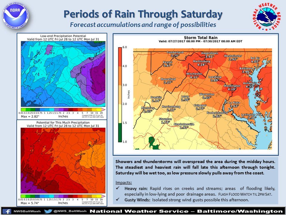
Those periods of rain will become heavier as the day goes on, into the evening and overnight hours. NBC4 meteorologist Chuck Bell says that rainfall rates of over 1 inch per hour are possible for several hours in a row.
This could lead to extremely dangerous travel conditions with high, standing water on roads and moderate to severe flash flooding in flood prone areas. The fact that the heaviest rain will be coming overnight only increases the risk.
As always, do not risk driving on water-covered roads. If you must travel Friday night, use extreme caution.
This is a potentially life-threatening event.
Flash Flood Watch
The National Weather Service has issued a Flash Flood Watch in effect from Friday afternoon through Saturday afternoon that affects the following WTOP locations:
- Calvert County, Maryland
- St. Mary’s County, Maryland
- Baltimore County, Maryland
- Anne Arundel County, Maryland
- Prince George’s County, Maryland
- Howard County, Maryland
- Charles County, Maryland
- Carroll County, Maryland
- Montgomery County, Maryland
- District of Columbia
- Alexandria County, Virginia
- Arlington County, Virginia
- Fairfax County, Virginia
- Stafford County, Virginia
- Prince William County, Virginia
- Loudoun County, Virginia
- Fauquier County, Virginia
Road conditions
The latest traffic conditions from WTOP
Current weather
function prepareFrame(){var t=document.createElement("wx:map");t.setAttribute("scriptId","wxMap"),t.setAttribute("memberId","1185"),t.setAttribute("mapId","0008"),t.setAttribute("templateId","0011"),t.setAttribute("latitude","37.9"), t.setAttribute("menuItems",'1101,0002,0009,0010'),t.setAttribute("longitude","-77.8"),t.setAttribute("zoomLevel","6"),t.setAttribute("standalone","true"),document.getElementById("custom_radar_map").appendChild(t)}$(document).ready(function(){prepareFrame()});The latest weather forecast from WTOP
Weekend forecast and beyond
Meteorologists predict the WTOP listening area could see as much as 3 inches Friday into Saturday, though some parts of the region could get 4 to 6 inches. The heaviest rain on Saturday will fall before noon but periods of moderate rain are likely to continue throughout the afternoon and well into the evening.
Much like in a winter storm, the higher precipitation amounts appear most likely from the D.C. metro area up Interstate 270 and out Interstate 66.
Forecast models have differing solutions for Sunday, though. While it’s likely to be dry by Sunday afternoon, there’s at least a 30 percent chance that showers could hang on into Sunday morning.
The real hang-up is the possible development of a second storm over the lower Chesapeake Bay Saturday night.
The strength of that storm is the wildcard — the stronger it is, the longer the rain will last into Sunday with higher rain chances remaining from the Bay to the beaches.
Monday through Thursday of next week will be mild and dry with temperatures trending back towards the average of 87/70.
Power outages
The post Batten down the hatches: Wicked weather on the way appeared first on WTOP.
